| Land Title Survey - ALTA/ACSM Survey Topographic Site Survey Control Survey Floodplain Determination & Certification |
|
| What is a Land Title Survey - ALTA/ACSM Survey? An ALTA survey is an American Land Title Association survey. This type of survey is a very detailed boundary survey that goes beyond the retracement of the deed record. This survey also includes the showing of improvements, utilities, usage, and many other items as are selected by the client. This survey addresses items that are noted on the title insurance commitment and attempts to explain those items. Click on the following link to view the current ALTA\ACSM requirements and Table A (page 6 of 9) for further information. |
Why do I need a Land Title Survey - ALTA/ACSM Survey? An ALTA survey is usually ordered by a lending institution when a piece of commercial property is being mortgaged or upon completion of a construction project in order to release the funds being secured by the project. On occasion, a lending institution will require an ALTA survey for a residential mortgage. |
| What is a topographic survey? A topographic survey is used to show the lay of the land. This type of survey uses vertical and horizontal data to generate a map (picture) of the property or area with contour lines that enable you to see the relief of a piece of property. Along with the contours, you will get a “snapshot” of the roads, utilities, and natural drainage. |
Why do I need a topographic survey? Designers of site plans, subdivisions, and utilities use this type of survey as a tool. A topographic survey is needed for drainage design, road design, parking lot design, and to calculate volumes of earth that need to be moved on a site. |
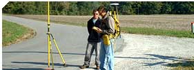
| What is a control survey? A control survey is a survey that provides horizontal and/or vertical position data for use by others on topographic surveys or mapping. |
Why do I need a control survey? Another surveyor or engineer, in order to complete a large project, could use a control survey. All survey companies do not have the same manpower situations or equipment resources, such as GPS. Because of this, they might need to hire a second survey company that has the resources to provide them with the necessary data. They can then take this localized data and complete their work in a timely and efficient manner. |
| What is a flood plain determination? A flood plain determination is a topographic survey of sorts, except that you are looking for a specific elevation. Once you have found the elevation that was determined by the governing body as the flood plain, you can proceed to locate the area and write a legal description of that area as being out of the flood plain. |
Why do I need a flood plain determination? If you are in a flood plain you are restricted in what you can do with your property. If you can get all or a portion of your property out of the flood plain you can regain the use of your property. If you are paying for flood insurance and your property can be determined to be out of the flood plain your lending institution will allow you to drop the flood insurance. |
 |
 |
 |
|
 |
|
|
|
|
|
|||
|
|
|
|
|